They were bracing for another storm, a tempest not nearly as powerful as the monster cyclone that devastated their island two years ago—but a storm nevertheless.
But before Tropical Storm Karen began to drench Puerto Rico on Tuesday with heavy rains, spawning mudslides and power outages, another natural disaster would rattle the nerves of residents still reeling from the effects of Hurricane Maria in 2017.
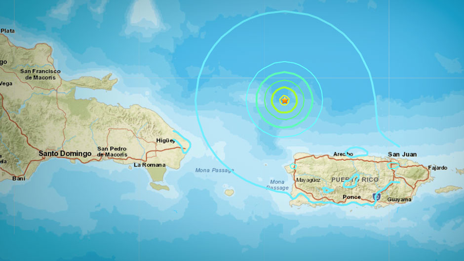
A magnitude 6.0 earthquake struck 49 miles off the U.S. territory’s northwest coast on Monday, jarring many people from their sleep. Three aftershocks, including a magnitude 4.7, hit within less than an hour, the U.S. Geological Survey reported.
No significant damage was reported, and after the quake, residents quickly refocused their attention on the approaching Karen.
Considering Puerto Rico’s location in the heart of hurricane territory, a temblor would seem to be the least of its worries. But the fact is, Puerto Rico experiences hundreds of earthquakes each year, said Guoqing Lin, a professor of marine geosciences at the University of Miami Rosenstiel School of Marine and Atmospheric Science.
“Puerto Rico is located on the boundary of the North American and Caribbean plates and is sandwiched between four seismogenic zones,” said Lin, referring to the U.S. territory’s location just south of the Puerto Rico Trench, the deepest part of the Atlantic Ocean with water depths exceeding five miles. “This diffuse and complex tectonic setting makes the island a seismically active region.”
The many temblors Puerto Rico experiences daily, however, are small—less than magnitude 3.0—and are never felt. “But seismometers still record the activity,” said Lin.
Monday’s earthquake was the strongest to hit the island since January 2014, when a magnitude 6.4 quake struck north of Puerto Rico’s north coast.
The most destructive earthquake to hit Puerto Rico occurred more than 100 years ago, when a 7.3 magnitude quake hit the island in October 1918, triggering a tsunami and killing 116 people.
“Locally generated tsunamis tend to be caused by large earthquakes near the coast, those above magnitude 7.0,” said Lin. “This one did not trigger a tsunami. Interestingly, it is believed that the Puerto Rico Trench is capable of producing earthquakes greater than magnitude 8.0.”
Even though the quake is now part of the region’s seismic history, seismologists will continue to monitor the area closely.
“For every earthquake there is a possibility that it is a foreshock to a bigger event,” said Falk Amelung, a professor of marine geosciences at the Rosenstiel School. “So for the next couple of weeks the likelihood for a big event to occur—in the Mona Canyon or along the megathrust—is higher than it was before the earthquake.”
Lin and Falk weigh in on some of the facts about Monday’s earthquake and the Puerto Rico Trench.
Where precisely did the earthquake that hit Puerto Rico on Monday occur?
The earthquake occurred in the submarine Mona Canyon just south of the Puerto Rico Trench. Its occurrence is related to the trench, but earthquakes are different. The Mona Canyon is a rift where the Caribbean plate is breaking apart. The earthquake was a normal faulting event, which is different from oblique-slip megathrust events we would expect under the trench.
—Falk Amelung, professor of marine geosciences at the Rosenstiel School of Marine and Atmospheric Science
What is unique about the Puerto Rico Trench?
The Puerto Rico Trench is a regular subduction plate boundary. The North American Plate dives under the Caribbean in an oblique-sense direction. The plate boundary is a megathrust fault that can generate very large earthquakes. Is it really dangerous? That is the question. There have been major earthquakes in the area, but none have been unequivocally tied to this fault. For megathrust faults, there are always two possibilities: The plate boundary may be uncoupled and sliding seismically against each other; or it is coupled, deforms, and stress is eventually released in a big earthquake. We don’t know which of the two models apply. Probably a combination of both.
—Falk Amelung, professor of marine geosciences at the Rosenstiel School of Marine and Atmospheric Science
There have been a few expeditions to the Puerto Rico Trench to learn more about it. But how much more remains unknown about the trench? Is there still a lot to learn?
We have known basic geological information about the Puerto Rico Trench through expeditions. However, regarding earthquake studies, we have learned so little about the subsurface structure and how the trenches and faults evolve and interact in this complex tectonic setting. For example, how the earthquakes are associated with the trenches and faults is still poorly understood, which is crucial for making realistic earthquake forecasts and thus reducing losses from earthquakes in the area.
— Guoqing Lin, professor of marine geosciences at the Rosenstiel School of Marine and Atmospheric Science
What other islands in the Caribbean are vulnerable to earthquakes spawned by seismic activity from the Puerto Rico Trench?
Besides Puerto Rico, the U.S. Virgin Islands and Dominican Republic are also in this seismogenic zone. The trench does not go as far as Haiti. The Puerto Rico Trench only extends to the northeast side of Dominican Republic and doesn’t go as far as Haiti.
— Guoqing Lin, professor of marine geosciences at the Rosenstiel School of Marine and Atmospheric Science