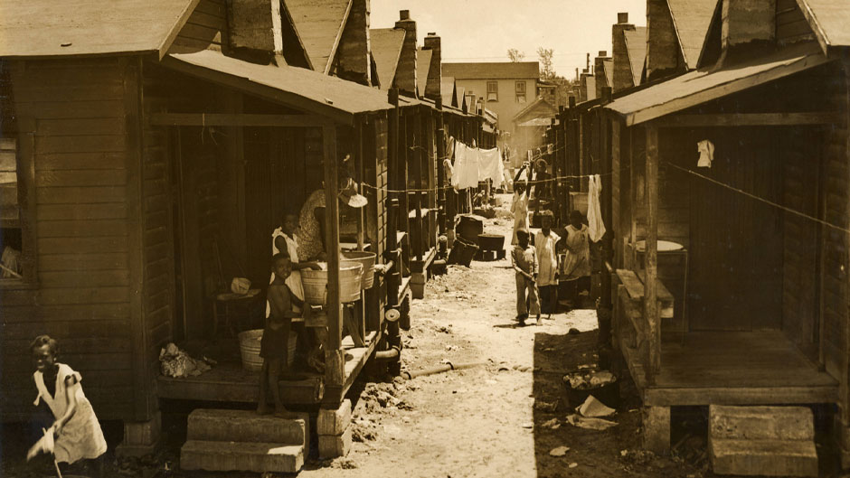
In 1939, after many African Americans living near Miami’s central business district were pushed out of “Colored Town” to Liberty Square, the Miami City Commission ordered the construction of a six-foot wall separating the South’s first Black public housing project from nearby white neighborhoods.
Though now only a few feet high, a remnant of that wall still runs along the Liberty City housing project, serving as a stark reminder of the strict color lines of the past and—as a new University of Miami digital history project shows—the outsized impact that racialized planning and zoning practices continue to have on Miami’s people of color.
“It was shocking to go through the history and see how minority communities were railroaded from home ownership, which is typically the basis for wealth in this country,” said junior Alex Hill, a history and political science major. “We may not be able to right the wrongs, but at least we can illuminate them, so people actually understand where the issues the city is facing come from.”
Hill was one of the nine students who produced Race, Housing, and Displacement in Miami for the Cities in American History course that Robin Bachin, the Charlton W. Tebeau Associate Professor of History, offered last spring with support from a Andrew W. Mellon Foundation CREATE grant and resources from UM Libraries. Bachin is also the assistant provost and founding director of the Office of Civic and Community Engagement, which is addressing South Florida’s current affordable housing crisis.
Using StoryMap, a platform that combines maps with narrative text, images, and multimedia content, the students spent the semester—which was disrupted and in some ways redirected by the COVID-19 pandemic—researching the library’s digitized archives, writing the histories of Miami’s segregation, slum clearance, public housing, and gentrification, and interviewing grassroots activists who today are fighting to build a more inclusive and equitable Miami. Along the way, they documented the historic policies and practices that public officials employed to remove Black residents from their homes and neighborhoods, paving the way for Miami’s glittering skyline and evolution into the de facto Capital of the Americas.
“By placing housing displacement at the center of Miami’s history of urban development, the students helped expose a past that is often ignored or forgotten,” said Bachin, who was as surprised as her students by the blatancy of some removal efforts. “It was striking to see how explicitly racist these practices were—that there was such a concerted and intentional effort to use any means necessary to get Blacks out of certain neighborhoods.”
From the razing of the long-forgotten Railroad Shop neighborhood to ordinances and covenants relegating African Americans to “colored” districts—where they were denied municipal services, housing loans, and building permits, and occasionally jailed for failing to keep up their properties—the means are spelled out in the StoryMap.
Named for the neighborhood that Black workers on the Florida East Coast Railroad established in 1898, Railroad Shop was a close-knit community with widespread home ownership. But using its powers of eminent domain, the city demolished Railroad Shop in the 1940s, so the nearby neighborhood of Allapattah had a place to build its all-white school.
Once called Colored Town, the lively Overtown neighborhood adjacent to Miami’s central business district, suffered the same fate, when in the 1960s business leaders, developers, and city officials elected to have Interstate-95 built right through its heart. The resulting demolition of hundreds of homes displaced thousands of people. Decades later, former Overtown resident Doretha Nichson still remembered the pain of losing what she considered her extended family in her “warm, loving, positive” neighborhood.
“I went to school within two blocks of my house,” Nichson said in a 2000 interview that the students found in Richter Library’s Special Collections. “I went to church within one block of my house, and my father’s and grandfather’s businesses was right down the street from my house and I knew everybody, you know, in the surrounding 10 square blocks.”
In 1999, hundreds more families were displaced from Miami-Dade County’s deteriorating Scott-Carver Homes, which were grossly underfunded after the barracks-style public housing complexes opened in the 1950s and were demolished with a promise: Former residents could move back into renovated housing. But during the decade it took to complete the mismanaged project, the county lost track of many of the former residents, prompting the Miami Workers Center to erect its own wall. This one listed the names of the people who had been displaced from Scott-Carver, and it demanded the county “Find Our People.”
Through interviews with modern-day grassroots activists, the StoryMap shines a light on contemporary discriminatory development patterns that are exacerbated by rising housing costs, and the threat of rising seas. One example is the gentrification of Wynwood, which in the span of a decade was transformed from a working-class neighborhood into one of Miami’s most popular tourist attractions. But as Milkeyka Burgos, of the Allapattah Collaborative noted in her interview, Wynwood’s eye-popping murals, craft breweries, art galleries, clothing boutiques, bistros, and late-night bars were built with little regard for the people who once called the neighborhood home.
“When you are able to kick people out of their own neighborhoods because of something that is benefitting people who are not from that neighborhood, that’s gentrification,” said Burgos, whose nonprofit supports wealth-building strategies for marginalized communities. “I’m not talking about redevelopment or making something nicer or prettier but creating goods and services and even buildings … that (don’t) match the demographics of the area.”
And now, the StoryMap notes, Wynwood’s rising property prices have led speculators to bet on the adjacent ethnic enclave of Little Haiti, which Haitian immigrants began settling in the 1970s. But, by the very names of their limited liability corporations—Vulture Property Investments, Strictly Profits, and World Domination Enterprises, to name a few—investors seem more interested in Little Haiti’s high ground than its people.
After all, unlike the nearby waterfront neighborhoods that are most vulnerable to rising seas, Little Haiti sits on a ridge. And, as the StoryMap also shows, it is among the neighborhoods most vulnerable to the novel coronavirus, which not coincidentally is killing people of color at a disproportionate rate—a fact tied to how and where they live.
“That’s part of the benefit of having this StoryMap,” said senior Haylee Privitera, a history and ecosystem science and policy major who worked on the StoryMap’s gentrification section. “We can show people the history of housing in Miami and the inequalities that have carried to the present. It’s all there. You can see it, and it’s pretty obvious what issues need to be addressed.”