
Geographic information systems (GIS) allow users to visualize, question, analyze and interpret data to understand spatial relationships, patterns and trends. The Department of Geography in the UM College of Arts & Sciences and UM Libraries are joining together to help the campus community discover the world through GIS on November 19, 2014.
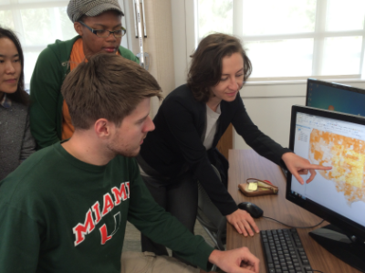 |
| Diana Ter-Ghazaryan, director of the Geospatial Technology Program, demonstrates the ESRI GIS mapping software to a group of students. |
The day-long event is UM’s celebration of GIS Day, “an international forum for users of GIS to demonstrate real-world applications that are making a difference in our society,” according to the official GIS Day website. GIS Day was launched in 1999 by ESRI a leading supplier of GIS software.
The program will begin with student-focused panels on job opportunities in GIS and securing a GIS-related internship. The afternoon sessions will feature UM faculty and local South Florida professionals with expertise in GIS, and a keynote address by Jacqueline Klopp of the Center for Sustainable Development at Columbia University. She will discuss the DigitilMatatus consortium, which produced the first mapping system for a quasi-formal transit system in Nairobi, Kenya.
The talk will showcase “the potential for open-source GIS mapping in Africa,” said Diana Ter-Ghazaryan, a lecturer in the Department of Geography and the director of the Geospatial Technology Program.
The Department offers both undergraduate and graduate certificates in geospatial technology. Both programs require five courses (15 credits), and can be completed in one year.
“GIS can be used to map anything that has an explicit or implied location,” Ter-Ghazaryan said, adding that she uses it for her own research on urban development and national identity in the Armenian capital of Yerevan.
“Its applications are endless for industries, and government,” she said, citing examples from regional planning, transportation, retail, utilities, natural resources, health and education. The range of applications is significant – from libraries using GIS for archiving photographs, to the recent inclusion of GIS in licensing requirements for civil engineers.
The program brochure states: “All issues that involve monitoring of the earth’s surface environment or processes, or involve exploitation of the earth’s resources, can benefit from geospatial technology.”
The UM certificate is unique in that it is a stand-alone program at the graduate level (although many students combine the certificate with other advanced degree programs, or with majors/minors in geography). In fact, the certificate program has formal arrangements in place with the Masters in Public Administration in the College of Arts & Sciences, and the Visualization Master’s degree program in the School of Communication. Certificate credits count toward both of these degrees.
The UM employee tuition remission program covers the graduate Certificate in Geospatial Technology.
The program was launched three years ago, and currently has close to 30 students. “We’ve had majors from across UM, from engineering to anthropology,” Ter-Ghazayan said, adding that graduates have gotten internships and jobs with Miami-Dade County, FPL Fibernet, National Geographic and the GIS company ESRI, among other organizations.
For more information about the certificate program, please visit GISC website. For more information about UM’s GIS Day 2014 Celebration, please visit: http://library.miami.edu/sp/subjects/gis/.
Leading up to GIS Day, the Department of Geography is sponsoring a student mapping competition, open to all UM students who have created maps for a UM course or their personal research. Up to three submissions will receive a $500 stipend from the department to use for academic travel. For detailed submission guidelines, please visit us HERE.
November 04, 2014