Ved Chirayath is on a mission to map the world’s oceans
Robert C. Jones Jr., 04-18-2023
One misstep and Ved Chirayath would have been a goner. Cut off from civilization and his cell phone useless, he knew that medical aid would never reach him in time if he were bitten by one of the countless sea snakes that surrounded him.
“They’re curious creatures,” the University of Miami researcher and National Geographic Explorer said of the highly venomous snakes. “They’ll swim right up to you and lick you. And when they sleep, they sleep head down in the rocks. So, my real concern was not to step on one.”
But despite the very real prospect of death, Chirayath concentrated on the task at hand: mapping a colony of stromatolites in Australia’s snake-infested Shark Bay.
He would spend the entire two months of that 2012 field campaign navigating around the deadly snakes, the thought of dying only occasionally entering his mind. His unquenchable thirst for knowledge allowed him to stay focused.
It’s that same thirst that drives him today in his quest to explore Earth’s last unexplored frontier: its oceans.
“We have mapped more of Mars and our Moon than we have of our planet’s seafloor, and we know more about the large-scale structure of our universe and its history than we do about the various systems in our oceans,” said Chirayath, the G. Unger Vetlesen Professor of Earth Sciences at the Rosenstiel School of Marine, Atmospheric, and Earth Science. “And we know so much more about our universe because we can see very far into space and in different wavelengths.”
Peering into the deep ocean, however, is another matter. Light penetrates only so far below the sea surface, and ocean waves greatly distort the appearance of undersea objects.
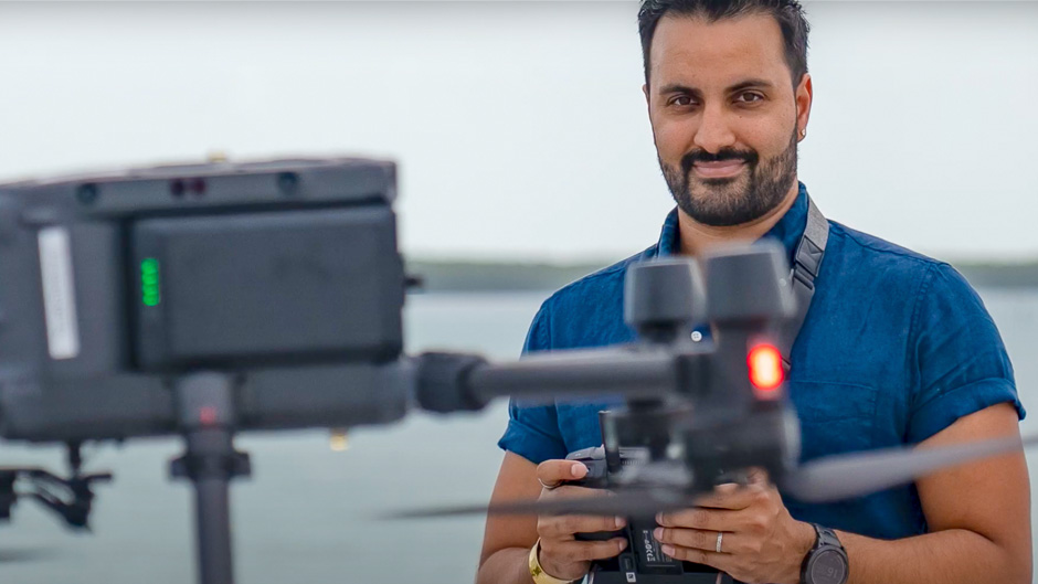
But using a camera he invented that literally sees through ocean waves, Chirayath is removing those distortions and helping to reveal the trove of deep secrets hidden by our oceans. Mounted on a drone flying above the water, FluidCam uses a technology called Fluid Lensing to photograph and map the ocean in remarkable clarity. From American Samoa and Guam to Hawaii and Puerto Rico, he has used the device to map more than a dozen shallow marine ecosystems such as coral reefs at depths as low as 63 feet.
“That still pales in comparison to the average depth of the ocean, which is nearly 4,000 meters. And 99 percent of the habitable volume of our planet is in that region,” said Chirayath, who also directs the Rosenstiel School’s Aircraft Center for Earth Studies (ACES).
Video content provided with permission by Ved Chirayath/University of Miami, Taylor Schuelke/National Geographic, and NASA. Produced by Franco LaTona/University of Miami
So, he created the more powerful MiDAR. The Multispectral Imaging, Detection, and Active Reflectance device combines FluidCam with high-intensity LED and laser light pulses to map and transmit 3D images of the sea floor at greater detail and depths. Chirayath’s research will be on display April 20–21 at the University’s showcase exhibit during the eMerge Americas conference at the Miami Beach Convention Center.
Recently, he used MiDAR to conduct multispectral mapping of corals in Guam, validating the airborne images during subsequent dives.
Still, even MiDAR will not illuminate objects 4,000 meters deep. But install the device on a robot sub that can dive thousands of meters deep, and the possibilities of imaging the seafloor in the same detail and volume that satellites have mapped land are limitless, according to Chirayath.
“It keeps me up at night,” he said of MiDAR’s potential. He envisions his creation, awarded NASA’s invention of the year in 2019, exploring not only the Earth’s deep oceans but worlds beyond—from sampling minerals on Mars to looking for signs of life beneath the icy ocean moons like Jupiter's Europa.
Stargazer
Chirayath’s fascination with studying and surveying the ocean deep was born out of his love of the stars.
He grew up in Los Angeles, looking up at the stars and contemplating the possibility of life on other planets. As a youngster, he would attend open house events at NASA’s Jet Propulsion Laboratory in nearby Pasadena, learning from the scientists and engineers who were building the Cassini space probe that explored Saturn and its intricate rings.
“I knew at 5 years old that I wanted to work for NASA and make a contribution to discovering other worlds,” Chirayath said.
By the time he was a teenager, astronomy had been his passion for more than half his life. It was also an escape, a methodology, he said, to deal with some of the challenges he faced at that time. “I was homeless for about three years, and I used that time to sit on top of a mountain and do as much astronomy as I could,” Chirayath noted.
At 16, he detected an exoplanet one and a half times the size of Jupiter and 150 light years from Earth in the constellation Pegasus, doing so with a consumer digital camera he modified and attached to a telescope. His refashioned scope allowed him to employ the transit photometry method for detecting exoplanets. Whenever a planet passes directly between a star and its observer, it dims the star’s light ever so slightly. Chirayath’s modified telescope detected just such a dip in light.
Earth- and space-based observatories that look continuously at stars for weeks and even months at a time use the technique. It took Chirayath three years to locate the planet, but his patience paid off in the form of a scholarship he won and used to help study theoretical physics at Moscow State University in Russia. He later transferred to Stanford University, where he earned his undergraduate degree.
To help pay the bills while he attended college, he worked as a fashion photographer for Vogue. His pictures have also appeared in Elle, The New York Times, and Vanity Fair.
He earned his Ph.D. in aeronautics and astronautics from Stanford University, reconnecting with his passion for astronomy and always asking himself, “What can I do with small telescopes? How can I make an impact? How can I develop new technologies and explore our solar system?”
He came to the University of Miami in 2021 after a decade-long career at NASA’s Ames Research Center, where he founded and led its Laboratory for Advanced Sensing, inventing the suite of next-generation remote sensing technologies that are now the cornerstones of his work at ACES.
While at NASA, he also created NeMO-Net, a single player video game in which players help NASA classify coral reefs. The space agency awarded Chirayath with its 2016 Equal Employment Opportunity Medal for organizing its first participation in the San Francisco LGBT Pride Parade.
The urgency to map
His fluid lensing mapping of the ocean promises to improve the resilience of coastal areas impacted by severe storms as well as assess the effects of climate change on coastal areas around the world.
While his origins are in astronomy, today he is more of a marine scientist than an astrophysicist. Still, the two fields are “incredibly similar,” Chirayath pointed out. “They’re both very difficult to study and require thinking beyond our terrestrial comfort zone. I love them both, and they can easily coexist. You can have large space observatories, and they can even help one another. A lot of the technologies that I’ve created were inspired by things I learned in astrophysics and applied astronomy. But there’s not that curiosity for understanding our own planet in a way that there is for space, and I’m hoping to change that.”
He applauds the $14 billion James Webb Space Telescope, which has been taking the deepest infrared images of our universe ever taken.
“But we’ve never invested $14 billion into an ocean observatory, into something that looks critically at a piece of the puzzle that if we miss, we do so at our own peril,” Chirayath explained. “I’m one of the many technologists who are looking inward and saying, ‘This is what we understand about the universe and its large-scale structure, but a lot of the questions that are being posed to understand our universe and what’s in it can also be posed for the ocean.’ If we don’t map it, if we don’t understand it, if we’re not able to characterize it, then when it fails or changes, humans may not be a part of the future.”
The University of Miami is a Titanium Sponsor of eMerge Americas. Visit the University’s research and technology showcase April 20–21 at the Miami Beach Convention Center. Registration for an Unlimited TECH Pass is free for all University of Miami students and faculty and staff members.