One of the first signs that the National Oceanic and Atmospheric Administration would predict a quiet Atlantic hurricane season emerged in early March, when the agency announced that the La Niña weather phenomenon that increases tropical cyclone activity had come to an end after three nasty years.
Conditions, they said, were trending toward an El Niño, a phase marked by warm waters in the eastern Pacific that can suppress Atlantic hurricane activity.
NOAA’s hurricane outlook became reality last week when forecasters with its Climate Prediction Center predicted a “near normal” 2023 Atlantic hurricane season, which runs June 1 to November 30.
That prediction, however, comes with a caveat. Warmer-than-average sea surface temperatures in the tropical Atlantic Ocean and Caribbean Sea could nullify that forecast, creating just the right conditions for an active storm season, according to a top University of Miami atmospheric scientist.
“If this were another La Niña year, we would expect a much bigger hurricane forecast season because conditions would be primed in the Atlantic for an enhanced year,” said Ben Kirtman, professor of atmospheric sciences at the University’s Rosenstiel School of Marine, Atmospheric, and Earth Science and the William R. Middelthon III Endowed Chair in Earth Sciences. “El Niño could keep us closer to near normal. But ocean temperatures in the Atlantic have just been so unusually warm.”
Kirtman—one of the architects of a first-of-its-kind meteorological tool, the North American Multi-Model Ensemble, which is used by NOAA in its hurricane forecasts—said those warm Atlantic waters can create more energy to fuel storm development and potentially cancel out El Niño conditions.
Other hurricane experts agree. “During El Niño, there is generally higher vertical wind shear across the tropical Atlantic as well as increased subsidence [dry sinking air], both of which are detrimental to hurricanes,” said Brian McNoldy, senior research associate and tropical cyclone expert at the Rosenstiel School. “However, a complicating factor heading into the season is anomalously warm ocean temperatures in the tropical Atlantic. If that persists into the core of the season, it will offer a boost to incipient waves as they exit the African continent, as well as throughout the Caribbean Sea and Gulf of Mexico. The added energy from the warmer water could end up dominating the effect of El Niño, or at least balance it out. Given these two opposing forcings, one word will be repeated in season forecasts: “uncertain.”
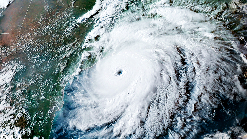
While NOAA reports that it has a 70 percent confidence in its ranges for the number of storms, a “near-normal” season does not mean powerful hurricanes will not form and make landfall this year. The 1992 Atlantic hurricane season is “the quintessential example,” McNoldy said. It was one of the least active seasons on record, producing only seven named storms, of which four became hurricanes.
“That was a very quiet season, but one strong hurricane formed and ended up making landfall in Florida as a Category 5 hurricane and leaving its mark on history,” he said, referring to Hurricane Andrew, which slammed into South Florida in August of 1992, becoming at that time the costliest and most damaging hurricane ever to hit the United States.
“Similarly, Anita made landfall in Mexico as a Category 5 hurricane in 1977. And Category 2 Hurricane Bob became one of the costliest hurricanes in New England’s history when it made landfall in Rhode Island during the quiet 1991 season,” McNoldy added.
That is why, according to Matthew Shpiner, executive director of emergency management, residents must remain vigilant and prepare for every hurricane in the same fashion.
“It only takes one,” he said. “As we approach the start of hurricane season, we continue to hear the stories of recovery eight months after Hurricane Ian hit the west coast of Florida. These experiences reinforce that when it comes to hurricanes, the storm is just the start.”
Upcoming research
NOAA’s 2023 hurricane forecast calls for 12 to 17 named storms (winds of 39 mph or higher), of which five to nine could become hurricanes (winds of 74 mph or higher), including one to four major hurricanes (Category 3, 4 or 5; with winds of 111 mph or higher).
But whatever the season holds, it promises to be a busy year for Rosenstiel School researchers, chief among them, Lynn “Nick” Shay, a professor of ocean sciences who studies warm water eddies that break off from the Loop Current in the Gulf of Mexico and supercharge hurricanes.
“A large warm eddy just separated from the Loop Current and is once again in phase for hurricane season,” Shay said. The 53rd Weather Reconnaissance Squadron out of Keesler Air Force Base in Biloxi, Mississippi, will deploy for Shay and his team up to five APEX-EM floats that measure temperature, salinity, current, and pressure in front of a hurricane.
“Our mission profiles are to sample between the surface layer and 300 meters as rapidly as possible for about a week to 10 days,” he explained. “And in collaboration with NOAA’s Hurricane Research Division, we will deploy expendable ocean and atmospheric profilers from NOAA’s WP-3D [Orion aircraft] over the float array before, during, and after a storm.”
Shay’s float array might also include satellite-tracked drifters and alamo floats, which measure temperature and salinity, in collaboration with the Scripps Institution of Oceanography and the Woods Hole Oceanographic Institution.
Using temperatures profilers known as AXBTs, Shay amassed a considerable amount of data on Hurricane Ian, which devastated parts of Southwest Florida last season.
“Ian started his intensification over the deep, warm layers of the Caribbean Sea and over the Florida Straits,” Shay noted. “The resultant temperature section along the track from aircraft showed that warm surface waters extended to the bottom all the way to landfall in 20 to 40 meters of water. As Ian moved over the shelf, the storm went through an eyewall replacement cycle, which significantly increased its intensity, allowing it to reach Category 4 status. In addition, Ian slowed down. With an expanded wind field and a slower moving storm that sensed the high temperatures from the ocean, Ian was destined to be a disaster and pile up the water leading to a surge of 15 feet at the Sanibel bridge. Three Hurricane Charley’s in 2004 could fit into the expanded wind field of hurricane Ian.”
With a National Science Foundation grant, Kirtman will study the dynamics of the La Niña and El Niño weather patterns. “Despite all the progress in predicting the two and the interest in how they work, we still don’t really understand why we get extreme ones. We don’t understand the physics behind that,” he said. “So, this new four-year project is an experimental design that will specifically try to sort out what determines the amplitude of La Niña and El Niño.”
Meanwhile, Sharan Majumdar, professor of atmospheric sciences, will visit the European Center for Medium-Range Weather Forecasts this summer to work on probabilistic predictions of hurricane formations for the 2023 season and to conduct retrospective evaluations of previous years. “Even though many of the most dangerous hurricanes have spawned from easterly waves that originate in Africa, it is still difficult to know whether a given easterly wave will form into a hurricane or not,” he said.
Also, Majumdar and his research staff and students are working on several projects related to hurricane formation, rapid intensification, modeling, satellite observations, and risk communication.
Jason Dunion, a scientist at the University of Miami Cooperative Institute for Marine and Atmospheric Studies, will again serve as director of the Hurricane Field Program, a collaboration between CIMAS and NOAA’s Hurricane Research Division. This year, NOAA is collaborating with the Office of Naval Research to study tropical cyclone genesis, how Saharan dust outbreaks affect tropical waves—which are “the seedlings for many hurricanes in the Atlantic,” he said, and the lowest parts of the tropical atmosphere just above the ocean called the boundary layer.
“We’ll be basing operations from Barbados and flying a few interesting instruments on the P-3 aircraft,” said Dunion, noting a special W-Band radar that can track water droplets in clouds and sea spray generated by hurricane force winds. “This will help us better understand tropical convection and how the atmosphere just above the ocean is affected by tropical cyclones.”
Among the other instruments to be deployed this hurricane season by Dunion’s team:
• A Wide Swath Radar Altimeter that will help observe waves in tropical cyclones, with data being sent in real-time to forecasters at the National Hurricane Center.
• Two small Unscrewed Aircraft Systems (sUASs) that will be launched from the belly of the P-3 in and around tropical cyclones. “One of the sUASs was launched for the first time into a hurricane during Hurricane Ian, and we’ll continue to test the capabilities of that drone this summer,” Dunion said. “The other sUAS, the Black Swift, is slightly smaller and has never flown in a hurricane environment. But we plan to test that capability this summer.”
• Skyfora dropsondes, which are smaller version of GPS dropsondes, will be deployed from NOAA P-3 and G-IV aircraft. “Both are mini weather stations that measure pressure, temperature, humidity, and winds,” Dunion said. “But Skyfora dropsondes are smaller and could potentially be deployed in swarms, so that we can collect more detailed measurements of a hurricane’s inner core.”
