Meteorologist Jason Dunion will never forget the time he felt like a feather in the wind aboard a Hurricane Hunter aircraft. It was during Hurricane Dorian, a 2019 storm that devastated the northern Bahamas.
“I felt like we were at the edge of Mother Nature,” he said.
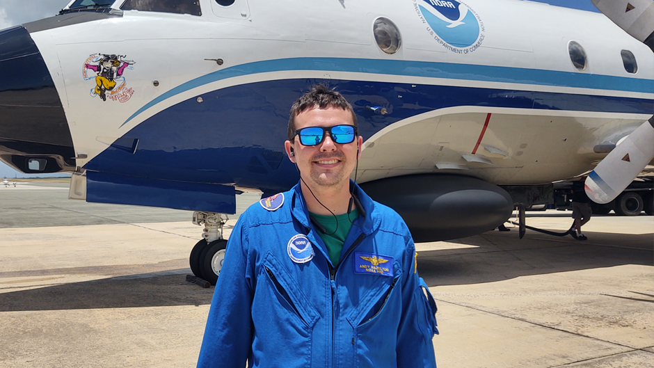
A year earlier, meteorologist Andy Hazelton recalls a flight through Hurricane Michael, where the gravitational pull of an updraft pinned him to his seat, and seconds later, a downdraft nearly sent him floating over it.
“It’s a roller coaster where you don’t know when the up and down will happen,” Dunion said.
And while being a Hurricane Hunter is a perilous job—one that includes extensive survival training—Dunion, Hazelton, and Kathryn Sellwood, all meteorologists at the University of Miami’s Cooperative Institute for Marine and Atmospheric Studies (CIMAS), feel their mild discomfort is a small price to pay for the incredible research they glean by flying through tropical storms and hurricanes to unveil more knowledge about how they form and intensify.
The three scientists are part of the National Oceanic and Atmospheric Administration’s (NOAA) 22-member Hurricane Field Program, run by the Atlantic Oceanic Meteorological Laboratory (AOML) on Virginia Key. They are motivated by the fact that their efforts collecting and sending data to the National Hurricane Center (NHC) and other agencies help keep people and property out of harm’s way. But these researchers also know that their efforts help advance scientific knowledge.
“There’s really nothing like seeing a real storm and what it’s doing—it makes everything real for me,” said Hazelton, an assistant scientist at CIMAS and at AOML. “Also, it’s rewarding that we are providing data to help people make decisions in real time and we are collecting this data to help forecasts and models improve in a lot of ways.”
Dunion is leading the field program for his fourth time this year. Along with Hazelton and Sellwood, they are part of a group of 10 CIMAS scientists who serve on the program and spend June through October ready to fly into the eye of a storm.
“Labor Day is a holiday we never get to celebrate,” Hazelton joked, explaining that it is usually during the peak of tropical activity.
With record-setting heat warming sea surface temperatures this summer, the team of scientists may be even busier in the coming months. Still, they remain eager to learn more about tropical cyclones.
“You can do all the research in the world between theory and modeling studies, but to actually see and measure some of these processes in action is really crucial,” said Sellwood, a senior research associate at CIMAS, and a data assimilation specialist at AOML.
For their bravery, the scientists earn a badge each time they pass through a hurricane eye wall. While Sellwood is up to about 130 badges, Dunion has about 75, and Hazelton has earned about 40. Despite the inevitable motion sickness that comes with the job, Hazelton remains excited to venture into the skies.
“Michael was the first time I was in a hurricane and could see the eye wall from the plane,” he said. “There’s really nothing like it.”
On each flight, a team of up to three scientists spend most of the eight-hour journey cleaning and transmitting data that is collected about every 15 feet in the storm. But they also are responsible for running experiments and leading collaborations with government agencies, including the National Aeronautics and Space Administration (NASA), and the U.S. Office of Naval Research.
“We support the NHC in Miami, as well as the NOAA Environmental Modeling Center, based in College Park, Maryland,” Dunion said. “We are constantly sending them data on the flights. But we are also trying to answer research questions like, ‘why is a storm intensifying so rapidly, or why does it change in structure?’ ”
As part of her daily job, Sellwood trains scientists in the Hurricane Field Program about the best ways to collect and prepare data from many instruments on the specialized aircraft. Her area of expertise is dropsondes, which are small tube-like weather stations that are released from the belly of the plane into the center of storms. They measure wind speed, humidity, temperature, and location every few feet before landing in the ocean. This year, Dunion said they may also be using new mini dropsondes that could be deployed in swarms.
Meanwhile, scientists on the Hurricane Hunter flights are also taking measurements using a tail doppler radar, seen as the best 3D measurement of a storm’s wind field, and Stepped Frequency Microwave Radiometer that senses microwave emissions from the ocean to measure surface winds. The three Hurricane Hunter planes crisscross through a storm in a figure four motion at least three times, if it’s safely possible.
FROM DATA TO FORECASTS
Beyond gathering data for immediate forecasts, University and NOAA scientists also hope that data collected on the Hurricane Hunter flights can improve the accuracy of hurricane models. These take measurements from past storms to predict the path and intensity of newly formed tropical cyclones.
“Comprehensive models have really become dependent on the data we are collecting,” Sellwood said. “And the resolution has really improved, so you can see the positive impact this data is having on the forecasts—that is really fulfilling.”
“The NHC uses models to create the forecast cone and they are typically more accurate with this data in it,” Hazelton added.
Recently, the NHC began using a new model that a team at CIMAS worked on for the past four years, called the Hurricane Analysis and Forecast System, or HAFS. The HAFS model relies on information gathered from past Hurricane Hunter flights and has shown a 10 to 15 percent improvement in track predictions, compared to other models. In experiments last season, the HAFS correctly anticipated the rapid intensification of Hurricane Ian, which devastated Southwest Florida. Hazelton and CIMAS software engineer Bill Ramstrom were part of the NOAA team that developed HAFS.
“We always want our research to be used in operational settings, so getting the HAFS in place this year was exciting,” Hazelton said.
A LAB IN THE SKY
This season, there are also about 24 active research experiments that the Hurricane Hunters are conducting, Dunion said.
For the second year, he will be taking a NOAA aircraft to Cabo Verde, off the coast of Africa, to measure and understand storms in their infancy. They also will be looking at the impact of Saharan dust outbreaks, which often interact with hurricane seedlings from Africa, called tropical waves, early in hurricane season.
In addition, the Hurricane Hunters are deploying the Altius drone for the second time this season. The small uncrewed aircraft flew through the eye wall of Hurricane Ian last fall, down to about 1,200 feet above the ocean surface for about three hours. There are also sail drones that can be dropped to float in the ocean beneath a storm.
“The boundary layer of a tropical cyclone is typically in the lowest 1,500 feet above the ocean,” Dunion said. “This is where you’re getting an exchange of energy between the ocean and the storm. So, with this technology we can study that process with a level of detail that we haven’t been able to do before.”
They also will be testing a new instrument called a “MicroSWIFT wave buoy,” which can be used to predict hurricane waves and storm surge impacts.
Dunion said the Field Program is invaluable and each season is intriguing.
“There’s so much you understand by being there,” Dunion said. “Every time I go, it brings up new questions. So, there’s that hands-on piece that you can’t replace.”