When reports from the Centers for Disease Control and Prevention (CDC) began linking COVID-19 and the nation’s most vulnerable populations, assistant professor and health geographer Imelda Moise set out to pinpoint where the highly contagious disease was being transmitted and contracted in Miami-Dade County.
Not surprisingly, she found on a local level what the CDC found on a national level—that disadvantaged people living in poorer neighborhoods are most vulnerable to the virus.
“Specifically, I wanted to know how the CDC findings translated here in Miami-Dade County,” said Moise. “I couldn’t stop thinking about where the spread was happening. Where is so fundamental to disease spread. When I started this research in July, Miami-Dade County was Florida’s epicenter, with 25 percent of the state’s cases. Our own well-being, including effective intervention and strategies to mitigate COVID-19 infections, now depends, at least in part, on geography.”
Given that COVID-19 cases continued to increase in Miami-Dade, and were reported only by zip code, city or on a national scale, Moise assessed COVID-19 risk on a much smaller scale by estimating overall COVID-19 rates at a census block group level, and indexing the social determinants of health (SDOH)—the conditions in the places where people live, learn, work, and play that affect a wide range of health and quality-of life-risks and outcomes.
“Once I created those indexes, I mapped them to help pinpoint which areas within the county had, for example, the most minorities, uninsured people, and single-headed households, in addition to high COVID-19 rates,” she said.
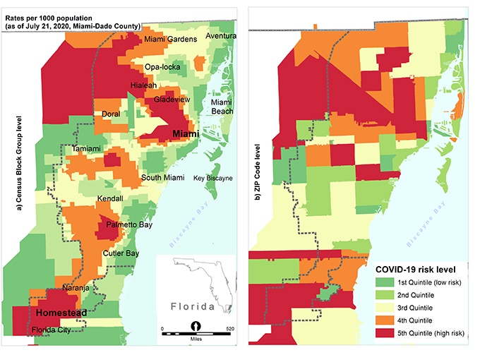
Using geospatial techniques, as well as SDOH measures from the U.S. Census Bureau and COVID-19 cases from the Florida Department of Public Health, Moise found that residents of census block groups with a high proportion of vulnerable and socially disadvantaged households, such as older people, uninsured or households with children under 18 years, were more exposed to COVID-19 compared to other residents in less socially disadvantaged census block groups.
“Mapping helped me to visualize not only the areas where the most disadvantaged individuals are located or converging, but also where the greatest COVID-19 burden and transmission rates were at smaller geographic units, which are mostly located in the north part of the county,” Moise said. “My study suggests a need to invest more in structural reforms such as provisions of temporary financial support to residents of neighborhoods that are socially disadvantaged. It is evident that residents of lower-income neighborhoods are more vulnerable, and this is not surprising because it is also being reported at the national level.”
Her study entitled, “Variation in Risk of COVID-19 Infection and Predictors of Social Determinants of Health in Miami-Dade County, Florida,” is now available online in the CDC’s journal Preventing Chronic Disease.