While cartographers were specifically tasked with charting land masses, waterways, and other geographic features of the world as they knew it, mapmakers of old often included a design element known as the “cartouche” to convey both symbolic and literal insights about the places and people depicted in their creations.
In a Libraries Special Collections webinar on Thursday, Chet Van Duzer, an author, historian and cartographer with the University of Rochester, explored the history and development of the cartouche, and detailed the symbolism found in a range of historic maps.
Arthur Dunkelman, curator of the University’s Jay I. Kislak Collection of the Early Americas, Exploration and Navigation, guided the “Frames That Speak” presentation and noted that the Kislak Collection contains hundreds of examples of the use of this unique cartographic design element.
“In the Open New Worlds exhibition, there are many, such as the circumnavigations of James Cook and the Polar explorations during the 19th century, showing hypothetical geography for unexplored areas—borders that were changed or distorted to suit a political agenda and how maps have been changed to reflect new information and discoveries,” Dunkelman pointed out.
The cartouche was used most notably from the 15th to the 19th century and served as a special communication between cartographer and the viewer. The messaging or metadata—either literal or symbolic information—was contained within a frame on the map, though that insertion was not necessarily a rectangle or a square, but could be composed of various objects, Van Duzer explained.
“It serves to abstract and epitomize some of the meaning of the work as a whole,” said Van Duzer, who defined the element as “a framing device containing text or decorative elements together with associated adjacent decorative elements.”
Mapmakers used the cartouche for a multitude of reasons, sometimes to convey a colonialist proselytizing message about an area of the world, as depicting mapped areas of Africa that were Christianized in light tones and un-Christianized regions in shaded dark.
Yet Van Duzer noted that paradoxically one of the purposes was for the cartographer to hide his geographic ignorance, such as inserting a large cartouche at the tip of South America [on a map of that region] to disguise that fact that the mapmaker was unsure whether there was truly a passage there or not.
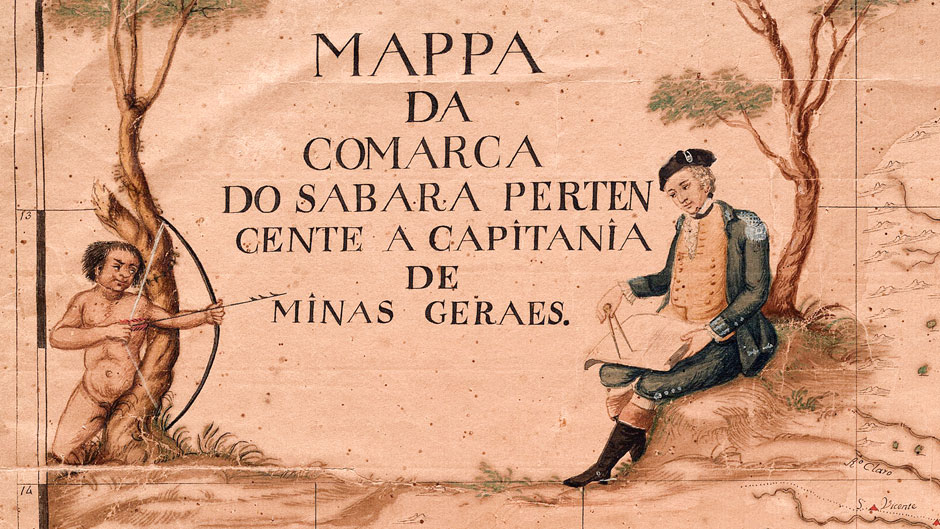
A succinct and powerful example of cartouche symbolism is found on the 18th century map of the Rio de la Plata by Portuguese cartographer José Joaquim da Rocha.
On the right, the cartouche depicts a European man making a map—most probably a representation of the cartographer himself—and on the left an Indigenous man pointing an arrow at the European mapmaker.
“Native peoples the world over had learned that when Europeans come making maps that tremendous colonial difficulties are to follow, appropriations and many other horrors,” Van Duzer explained. “This image sums up the hostility between native peoples and European cartographers, and implicit in the former's knowledge of what comes when European mapmakers come mapping regions that belong to Indigenous peoples.”