The violent winds and that “terrible howling sound” had subsided by dawn, a clear indication to Hans Graber that the small but powerful storm had passed.
But when the University of Miami researcher, his two young sons, and his pregnant wife emerged from their home’s bathroom, where they took refuge for four hours on the early morning of Aug. 24, 1992, the nightmare was just beginning.
Hurricane Andrew’s ferocious winds had ripped away 70 percent of the roof, turning every room inside his family’s southern Miami-Dade County home into shallow wading pools. Tiles dislodged from a neighbor’s roof had flown in every direction, shattering nearly all the home’s windows. Graber’s entire neighborhood, in fact, was in ruins.
Special Feature: A ferocious cyclone, Hurricane Andrew helped launch a new era of storm research
Read: Off the western coast of Africa, a nursery ground for powerful storms exists. A University of Miami researcher recently traveled there to study it.
“It looked like a war zone,” said Graber, a professor of ocean sciences at the University of Miami Rosenstiel School of Marine, Atmospheric, and Earth Science.
The road to recovery, he knew, would be a long one.
Graber and his family moved in with his wife’s brother in a nearby Miami suburb, and then into a Miami Beach condo, while workers repaired their storm-ravaged home. It would take a year to rebuild.
His family’s ordeal, which ABC’s “Good Morning America” documented in its Hurricane Andrew coverage 30 years ago, only strengthened Graber’s resolve. It also taught him a valuable lesson on the urgency with which relief and recovery efforts must begin in the immediate aftermath of a storm.
Nine years later, he would help launch and take the reins of a new Rosenstiel School facility that would help first responders reach storm victims faster.
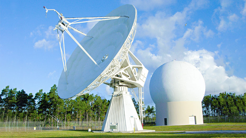
Among its myriad responsibilities, the Center for Southeastern Tropical Advanced Remote Sensing (CSTARS) collects and processes satellite imagery of environmental conditions in the southeastern United States, Gulf of Mexico, Caribbean Basin, and Equatorial Atlantic, getting that data into the hands of people involved in rescue efforts.
Immediately after Hurricane Katrina devastated coastal areas in Alabama, Louisiana, and Mississippi on Aug. 29, 2005, the Federal Emergency Management Agency (FEMA), U.S. Coast Guard, and state and local officials used the near real-time satellite imagery provided by CSTARS to learn which roadways were impassable, to locate heavily flooded residential areas, and to determine the extent of damage to seaports and airports.
“Could they land conventional aircraft at the airports, or would they need vertical lift helicopters to fly in relief supplies? What streets were clear, and where was the dry higher ground located? That’s the kind of lifesaving information our center was able to supply through critical satellite imagery,” said Graber, who has directed CSTARS since its inception.
Located in south Miami-Dade County and equipped with two satellite receiving dishes, CSTARS also provides data that helps researchers learn more about the dynamics of hurricanes. Last year, for example, professor of ocean sciences Roland Romeiser received an Office of Naval Research grant to provide both satellite imagery of hurricanes making landfall in the continental U.S. and high-resolution maps of surface conditions over the ocean and land to modeling teams at the National Oceanographic Partnership Program, which they would use to estimate storm surge impacts.
“We’re starting to gear up for the next hurricane that will hit the U.S.,” Graber said. “Our goal is to provide information even faster to various agencies like FEMA and to local and state first responders.”
As for Hurricane Andrew, he will always remember riding out the storm with his family in the bathroom and hearing the “terrible howling sound” made by the storm’s Category 5 winds. Graber’s wife, who was seven months pregnant at the time, gave birth to a daughter two months after Andrew hit.
Graber has now lived through three hurricanes. “And each one,” he said, “has reminded me of the damage they can inflict and why it is so critically important to get the information out there that’s needed for first responders.”