In his presentation, “Indigenous Cartography and Cartography of the Indigenous,” data scientist Timothy Norris highlighted the cultural discourse and indigeneity tensions that mapmaking has generated, especially over the past three centuries.
“All maps are political statements that have the intention to change the world in one way or another,” said Norris, who holds a joint appointment with University of Miami Libraries and the Institute for Data Science and Computing (IDSC). “Any conversation around maps and indigeneity is going to be extraordinarily controversial.”
Norris’ virtual presentation on June 1, the fifth in the University Libraries’ series “Conversations on Cartography,” was moderated by Arthur Dunkelman, curator of the Jay I. Kislak Collection.
In exploring the crossroads between cartography and indigeneity, Norris drew on his research of geospatial data visualizations (cartography) and participatory research methodologies, as well as from his experience teaching a class by the same title offered by the Native American and Global Indigenous Studies program.
He emphasized that maps are made for a myriad of reasons, not simply to aid travelers.
“Maps are often about boundaries and measurements and either some kind of government management or statecraft—taxes, surveying, or something similar—and, more recently, about property and how we maintain it,” he said.
The concept of property was essentially a Western concept, mostly unknown to Indigenous people. Norris categorized Indigenous cartography as either ancestral, anti-colonial, or de-colonial, a school of thought that aims to delink from Eurocentric knowledge hierarchies.
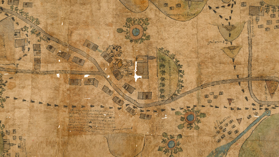
In assessing the San Juan Tolcayuca map of Mexico, a late-17th century specimen crafted by Náhuatl artists, he noted that, like most early maps, it was most probably commissioned by local authorities at the time to resolve a land claim.
“One of the things I really liked about this image is that it seems to be participatory,” he pointed out. “There’s a consultation going on between the locals and the Spanish friars, and more than one worldview being presented. It’s neither just Spanish nor Indigenous, but instead a hybrid world view—an encounter.”
The Mercatur Gerhard world map of 1569 revolutionized navigation and opened the doors of exploration on a global scale, Norris said. Sea captains could now leave one port and, following the lines of constant bearing detailed on the map, end up approximately on the same shoreline a great distance away.
Norris highlighted two of the map’s remarkable effects.
“Besides the negative effect it had on peoples, particularly in the Americas, one is that the Mercatur projection system is still used today [for navigational mapping] and the other is the way that Indigenous people were portrayed in the cartography,” he said.
Norris offered the 1814 map cataloguing the Lewis and Clark Expedition as a prime example of the “cartography of the Indigenous.”
The map showed Lewis and Clark’s route traversing the United States using horses and canoes and included tribes’ names and numbers—examples of anthropological field work—and much like the Mercatur map could be celebrated as an extraordinary human achievement, he noted. Yet it does not appear to be participatory.
“This map did an enormous amount of damage to the people that Lewis and Clark relied on to make the map from all accounts,” Norris noted. “People gave them horses so that they could travel faster, there were many accounts of tribes providing shelter and food on the way. Indeed, almost all of them were friendly—then this map got turned into a weapon against almost all of them.
“The expedition symbolizes a devastating U.S. citizen invasion that challenges the Indigenous peoples’ ways of life. That’s a clear way of understanding that it was an invasion,” he said.
Norris highlighted the assertion by Bernard Nietschmann, a University of California at Berkeley geography professor, that “more Indigenous territory has been claimed by maps than by guns.”
“When I was younger and heard these words they influenced me enormously,” said Norris, who worked with Nietschmann for a time. He suggested that a corollary statement should also hold true: More Indigenous territory can be reclaimed and defended by maps than by guns.
Norris highlighted recent news from Brazil where Bill 490, legislation that would block all new recognition of Indigenous lands, has moved through the lower houses of congress. If passed, more than 400 pending claims would be summarily dismissed.
“It’s important to talk about these indigeneity encounters that continue to advance in Brazil and elsewhere in the present day,” Norris said. “These rights and resources are still being defined, and it’s important to keep in mind how these processes are undertaken.”