LOWER MATECUMBE KEY, Fla.—As a teenager, Kathleen Sullivan Sealey spent summers at her grandmother’s house in Key Largo, snorkeling along Tavernier Creek and into the Atlantic Ocean.
By simply wading in with a mask and fins, Sealey was transfixed for hours, swimming above the lush green sea grasses, purple sea fans, and pipe-like orange sponges growing from the rocky limestone sand. A little farther offshore, she swam up to coral reefs brimming with marine life.
Years later, when she became a biology professor at the University of Miami in the 1980s, Sealey would introduce her students to the nearshore coral ecosystem by driving south to the Keys, pulling her car off the road, donning her snorkel gear, and hopping in.
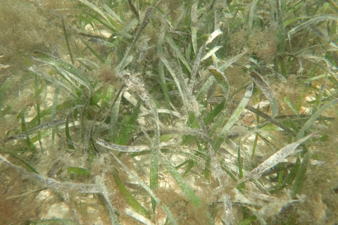
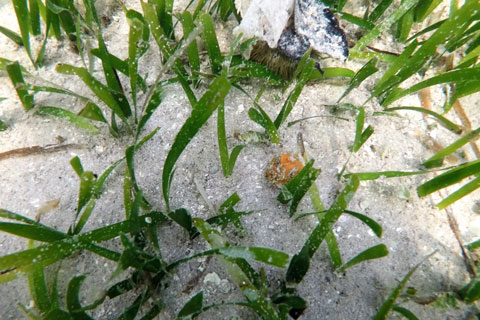
While the serenity of the Florida Keys still entrances Sealey today, the colors of the nascent plants and animals lining the shores of the archipelago are less vibrant. The shallow waters support small patches of seagrass beds that are home to baby fish, crabs, and shrimp, but compared to their previous green luster, now they are often brown and muddy.
The water is cloudier too, reducing the amount of light reaching the seagrass. And Sealey, who has devoted her career to coastal ecology, is working with her students to inform Monroe County officials just how much the waters that hug the Keys—and the wildlife that blossoms there—have been transformed by the development of residential canals.
“I used to be able to see all the different types of nearshore coral within 100 yards of the shoreline,” she said. “But now, those places don’t exist.”
Sealey and a team of graduate students, led by Ph.D. candidate Jacob Patus, recently finished a two-year project funded by Monroe County and the Florida Department of Environmental Protection to survey the waters in and around 13 different canal sites throughout the Keys. They hope to get a sense of the current nearshore water quality and to determine if it has improved since 2017, when the county finished implementing a massive wastewater system to replace thousands of septic tanks that were likely leaking nutrients and other pollutants into the ground. These contaminants inevitably found their way from the porous limestone into the coastal waters, Patus and Sealey believe.
“Monroe County wants some scientific data to answer the question of how much pollution is being created by residential canals, so we are trying to provide them with that,” Sealey said. “The idea is that once they have this knowledge, they can implement mitigation plans to improve canal water quality.”
At the same time, the team is also trying to narrow down why some canals are cleaner than others.
Roots in the region
Sealey’s work in the Keys stretches back more than 20 years when she helped create a database of the archipelago’s more than 500 canals, with information on when they were constructed, along with the length and depth of each waterway. Her work, and the research of others, determined that some of the most harmful man-made contaminants are trapped in the canals, which are often used as roads for boaters.
The reasons are plenty. First, Sealey said that canals were dredged out from the limestone starting in the 1940s through the 1980s to create water access for homes and marinas. As part of that effort, mangroves were removed without regard for the environmental damage that it did to the fragile Keys ecosystem.
Then, as storms and rain passed through, the nutrients from cleared land and development trickled into the deep canals, where the harmful nutrients accumulated. This created the backdrop for some of the algae blooms that occur today. In addition, as patches of sargassum seaweed have been proliferating since 2011, the floating masses often get trapped in the canals.
When these outside elements are carried into canals, they decompose and the stagnant waterways are unable to flush out the harmful nutrients, contributing to poor water quality. “The worst levels of nitrogen and phosphorus are in the canals,” Sealey said. “Especially near the bottom of the deeper canals.”
That’s why county officials want to focus on those thoroughfares first. Yet another driving force behind their efforts is the Florida Impaired Waters Rule, or a state environmental law that outlines levels of nutrients that can be present in the water before it is deemed environmentally unsafe.
If samples show that certain levels are higher than what is considered “safe,” local cities and counties must mitigate the situation, or face fines for the environmental harm. Therefore, by conducting this study, the county is trying to be proactive and improve water quality in its most concerning spots, according to Sealey.
Unfortunately, identifying the source of water pollution is less clear cut. Although the new Monroe County sewer system has likely improved water quality, simultaneous development and climate change—which are raising water temperatures and prompting sea level rise—are now also impacting the water quality and its inhabitants, Sealey added.
“Anytime you have flooding you are going to exacerbate the problems of coastal pollution,” she explained. “And sea level rise will only carry more debris from land right into the ocean and increase nearshore water quality problems.”
Gauging water cleanliness
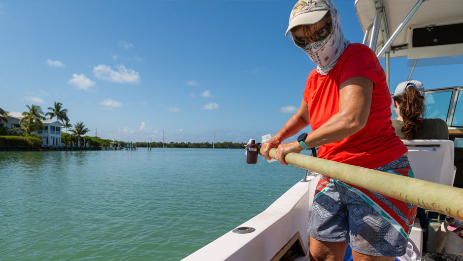
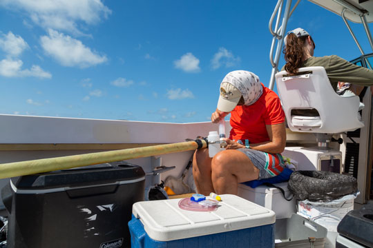
As an osprey circles overhead, Sealey guides a long fiberglass tube holding clear plastic sample bottles over the edge of an open fisherman boat, dunks them into the murky water of a canal, and guides them back into the boat. She then filters half of the samples with a fiber filter, while the others are left unfiltered. The process helps identify nutrients that are dissolved in the water from nutrients carried in particulate matter.
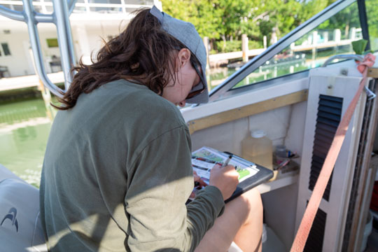
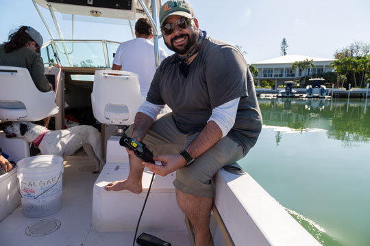
At the same time, Patus drops a probe into the water, measuring the temperature, depth, salinity, dissolved oxygen, and pH in the water. He calls out the measurements to graduate student Ashley Goncalves, who scribbles the numbers down on a label, along with the location, time, and date. She then passes the label to Patus, who affixes it onto each bottle Sealey hands him, and then drops it into a cooler full of ice.
The trio replicate the pattern about 16 times throughout the morning, inching farther out from the mouth of the canal 500 yards into the open water. It is a task they have repeated each quarter from Key West to Key Largo, and this is their final trip.
Once they return to Miami, Patus will shuttle the samples to a lab certified by the U.S. Environmental Protection Agency. Using the lab data, Patus will enter the information into a scoring system he created. One of the most telling water quality parameters in the canals is chlorophyll, Patus noted, because the canals with the most pollutants in them often have an overabundance of the green phytoplankton, or single-celled plants.
“Low chlorophyll is a more ideal situation, so then there’s less plankton in the water stealing oxygen from other marine organisms,” he said. “This also ensures the water is clearer, so light can reach the seagrass—more chlorophyll often means less seagrass.”
Looking for bright spots
Patus and Sealey are now in the process of scoring all 13 canals, some of which open up to the Atlantic Ocean on the eastern side of the Keys and others to Florida Bay on the western side.
“We have some canals we can point at that are benefiting from [coastal] management and others that need more attention,” Sealey pointed out.
Although the data varies widely, Patus said one trend they have noticed is the farther south canals are from mainland Florida, the better their water quality. However, Sealey and Patus noted that they have only surveyed a small fraction of all the canals. After fully analyzing the results, they will share the data with the Monroe County Commission in the fall.
“Another thing we have noticed is if you have a canal with poor water quality, the worst spot is at the mouth of the canal,” Patus indicated.
|
|
There are already several ideas for how to improve water in the canals, and the county is testing out some of them. One idea includes installing a solar-powered “air curtain,” which releases bubbles at the mouth of the canal to oxygenate the water better. Other potential improvements include putting plastic barriers at the mouth of canals so that less seaweed will float into them and get trapped, or even filling the canals so they are shallower. The county has also considered asking homeowners to plant mangroves and build up their seawalls to help counter sea level rise.
“Ideally, what we are doing should help show the county the areas that need to be targeted, so that they put a higher priority on remediation in certain canals,” Sealey said.
Regardless of what the Monroe County Commission decides to do, Sealey is glad that they are taking water quality seriously. Left unchecked, she stated, water pollution could destroy the beautiful marine ecosystem that attracts so many to the Keys.
“We’ve noticed that where there’s bad water quality in the canals; there tends to be less diversity in the marine plants and marine organisms just outside the canals,” she said. “We’ve also noticed that there’s been a shift in environmental conditions. So, while there used to be a hard limestone bottom at the shore with sponges, corals, and seagrasses growing from it, the nearshore communities are now shifting to less diverse algal communities.”