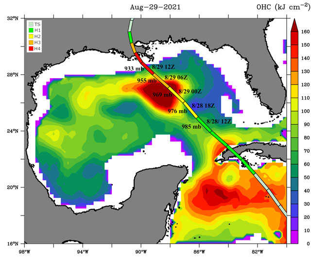
Ida’s transformation into the monster hurricane that would devastate Louisiana had still not occurred. It was Saturday, Aug. 28, a day before the 16th anniversary of Hurricane Katrina, and the storm was still only a Category 2 cyclone when University of Miami physical oceanographer Lynn “Nick” Shay went to bed late that night.
But as the storm moved into the northern Gulf of Mexico, tracking ever closer to the Bayou State, it started to bulk up. And by the time Shay awoke at 8 a.m. Sunday to get the latest storm telemetry, Ida had intensified into a dangerous Category 4 hurricane; its top winds going from 115 mph to 145 mph in just a few hours.
That Ida intensified so quickly didn’t surprise Shay at all. A professor of ocean sciences and associate dean of research at the Rosenstiel School of Marine and Atmospheric Science, he had seen such rapid intensification occur in other hurricanes before; and in many of those cases, knew what caused the phenomenon: an enormous circular pool of warm water called an eddy.
“For many coastal communities in the Gulf, their formation during hurricane season can lead to catastrophe,” said Shay. He noted that at any one time, as many as three eddies are circulating in the Gulf of Mexico.

In the days leading up to Ida’s U.S. landfall, Shay had been watching one particular eddy very closely, using satellite imagery to track its movement and position. Nearly 125 miles across, it had separated from the Loop Current. An area of warm water that travels up from the Caribbean, past the Yucatan Peninsula, and into the Gulf of Mexico, the current is known to shed massive eddies that retain considerable amounts of heat, turbocharging hurricanes that pass over them. And that’s precisely what happened as Ida headed up the Gulf before making landfall near Port Fourchon, Louisiana, on Aug. 29—the storm passed directly over an eddy packing surface temperatures over 86 degrees Fahrenheit, Shay discovered.
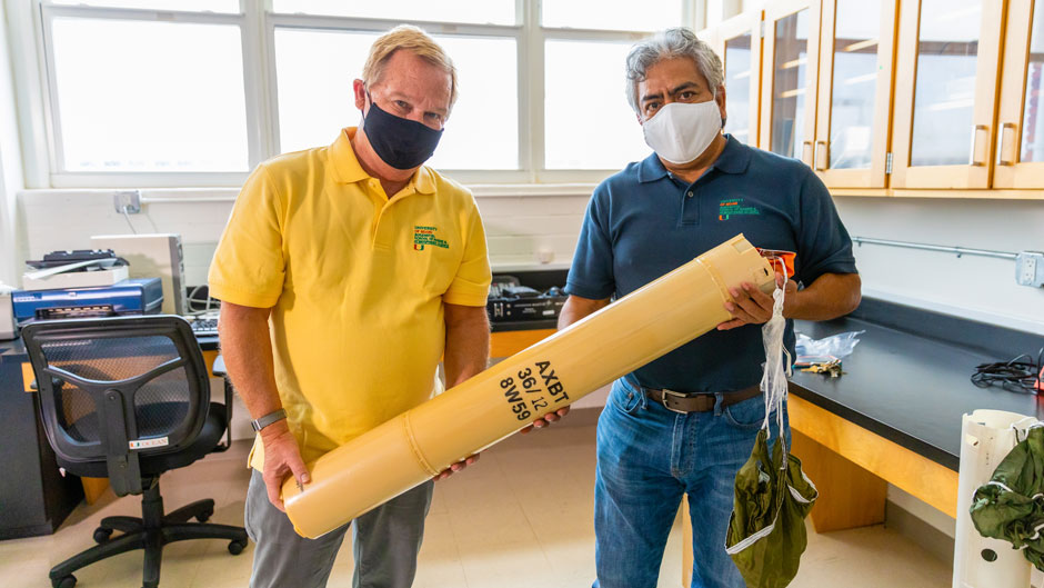
Ocean-monitoring devices that can descend as deep as 2,500 feet revealed that the eddy also contained heat down to approximately 480 feet below the surface. So, even if Ida’s winds had resulted in some upwelling—bringing deep, cold water to the surface—the eddy was going to retain heat, providing the high-octane fuel the storm needed to intensify, Shay said.
Like watching reruns of an old television show, Shay has seen this scenario play out before, with Hurricane Opal in 1995 being a “tipping point,” he said.
“When forecasters were looking out over the Gulf of Mexico, they were just looking at a sea surface temperature image, and it was pretty much uniformly warm,” Shay recalled. “Opal was meandering down in the Bay of Campeche, and no one really thought about it deepening and having a big impact in the Gulf. But suddenly, it started taking off toward the northeast and right over a warm eddy that had separated a few months earlier. It exploded. It went from a minimal hurricane to a Category 4 within 12 hours or so. So, it took forecasters totally by surprise.”
The 15th named storm and ninth cyclone of the active 1995 Atlantic hurricane season, Opal caused widespread damage along the northern U.S. Gulf Coast in October 1995. It destroyed hundreds of homes in the Florida Panhandle and left millions in Alabama without electricity.
Now, more than 25 years later, forecasters are paying a lot closer attention to warm water, and Shay’s pioneering work in studying these currents is a big reason why. He’s flown on a multitude of scientific missions aboard Hurricane Hunter and C-130 Hercules aircraft, releasing probes into the ocean that collect and transmit critical data on the upper ocean and air-sea interactions.
During the then record-breaking hurricane season of 2005, Shay and his team of researchers were especially busy, flying into the maelstrom of two of history’s most notable storms—hurricanes Katrina and Rita, both of which, like Ida, were supercharged by warm-water eddies.
“For Katrina, we deployed a slew of sensors to map out an eddy, the winds, and atmospheric parameters,” Shay noted. “The original forecast had the storm cutting across Miami-Dade County and then making a hard right and going right up over the west Florida shelf. We knew where the Loop Current was. We knew that it was going through a bulge and that it was getting ready to separate an eddy, and it did. And Katrina followed that path and explosively deepened. Then, a week and a half later, we were back out again, flying through Rita,” he added.
“So, we’ve seen this show several times; we know what to expect,” Shay continued. “With Ida, some of the thinking was that dry air was going to make it into the Gulf, but that didn’t happen, and that wind shear was going to remain high, but that didn’t happen either. What was left was the fact that Ida’s circulation was getting its act together. There was nothing but warm water in the Gulf of Mexico, and there was this big, warm eddy sitting right in the target zone. We saw it coming.”
Shay studies eddies year-round, knowing quite well that these circular currents of warm water can not only supercharge tropical cyclones during the warm summer months, but also influence weather patterns during other times of the year. That may have been the case during the so-called Storm of the Century in mid-March of 1993, when an intense storm system ravaged the eastern coast of North America as it moved from the Gulf of Mexico to Canada, causing record snowfall in some areas and killing more than 250 people.
“Eddies in the Northern Gulf of Mexico can help fuel these strong atmospheric fronts that come through in the winter months,” Shay explained. “We’ve looked at some of the previous frontal storms, and it looks like the 1993 Superstorm just got such an energy boost from a warm eddy in the Gulf.”
Shay has been studying the dynamics of hurricanes for more than four decades, sowing his seeds in the field in Bay St. Louis, Mississippi, in the late 1970s, when he worked as a physical oceanographer for the Naval Oceanographic Office. During the summer months of 1979, he deployed a series of moorings in the Northeastern Gulf of Mexico near the DeSoto Canyon, and those ocean-monitoring buoys captured a wealth of data on sea-surface temperature and current when the Category 4 Hurricane Frederic passed directly over them. “That got me hooked,” Shay declared. “Frederic was really the first storm I studied extensively, and I was able to produce a fair share of scientific papers on it. And the rest is pretty much history.”
From studying how hurricanes affect red tide outbreaks to conducting research on how storms influenced the flow of petroleum from the Deepwater Horizon oil spill, Shay’s research runs the gamut. While 65 percent of his work is focused on the Gulf, he has also studied currents in the Eastern Pacific. And his team has a suite of high-frequency radars deployed along the South Florida coast, mapping currents, winds, and waves in real time.
“We have an enormous set of surface-current data measuring the Florida Current across the Straits of Florida, looking at the small-scale eddies and the Florida Current itself and the large-scale eddies on the other side of the Straits,” Shay explained.
The oceanographer’s research has been funded by the Office of Naval Research, the National Science Foundation, the National Oceanic and Atmospheric Administration (NOAA), the Gulf of Mexico Research Initiative, the Bureau of Ocean Energy Management, and NASA. He has published more than 120 peer-reviewed articles in top-tier journals and collaborated with scientists at universities and government and private-sector laboratories around the nation.
Shay emphasized that his work is a team effort involving a diverse group of scientists in his Upper Ocean Dynamics Laboratory, including associate scientist Benjamin Jaimes de la Cruz, senior research associate Jodi Brewster, and research associate Jorge J. Martinez-Pedraja.
“Our partnership with NOAA’s Hurricane Research Division led by Frank Marks and our relationship with NOAA’s Aircraft Operations Center in Lakeland, Florida, have been invaluable over the past few decades as well,” Shay said. He also noted the contributions of current and former students Eric Uhlhorn, Daniel Jacob, Joshua Wadler, Patrick Meyers, Johna Rudzin, Claire McCaskill, Michelle Mainelli, and many others.
As much as Shay knows about eddies and currents, the breadth of knowledge in that field of study still needs to be expanded, he said. He and a team of scientists from multiple institutions could get a big boost in that area should their grant proposal to examine the dynamics of the Loop Current come through.
“We don’t have the clearest picture on eddy-shedding behavior, but we know it occurs,” Shay said. “We need more measurements and models to understand it, because ultimately, our goal is to improve forecasts and save lives.”

