From the deck of the research vessel Neil Armstrong, oceanographic researchers deployed the massive air-sea interaction spar (ASIS) buoys off the coast of Santa Rosa Beach in late January, watching as the instrument-laden devices began to float upright in Florida’s northern Gulf of Mexico waters.
There, the buoys will remain for the next several weeks collecting valuable information on land, air, and sea interactions that affect storm surges, wind fields, and other weather events.
It is all part of a nearly $7 million study led by the University of Miami Rosenstiel School of Marine, Atmospheric, and Earth Science that will help the U.S. Navy improve its high-resolution weather forecast model—the Coupled Ocean/Atmosphere Mesoscale Prediction System.
“Waves and winds behave quite differently in coastal areas than in the open ocean. But unfortunately, there’s a paucity of research data on those complex interactions,” said Brian Haus, professor and chair of ocean sciences and the lead investigator of the $6.74 million Coastal Land-Air-Sea Interaction Experiment.
As part of the five-year experiment, which is funded by the Office of Naval Research, researchers deployed a multitude of buoys offshore in Monterey Bay, California, and Santa Rosa Beach, Florida. Sampling from a network of land-based flux towers, aircraft, radars, drones, and satellites is augmenting the data recorded by the buoys. The goal, according to Haus, is to better understand the dynamics of winds and waves in the critical zone about four miles from sandy, rocky, urban, and mountainous shorelines.
“It’s been known for quite some time that operational wind forecasts for various models have been deficient at the coastal boundary,” he said.
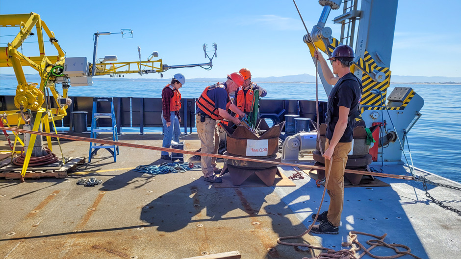
The 40-foot-long ASIS buoys, which are equipped with special monitoring instruments, play a pivotal role in the experiment, remaining at sea for weeks to collect crucial data.
Eight of the buoys were shipped in pieces from Miami to Alameda, California, then assembled onshore and transferred to the research vessels Sally Ride and Roger Revelle, both operated by the Scripps Institution of Oceanography out of San Diego, for ocean deployment during a series of expeditions to Monterey Bay, California, in June 2021 and October 2022. Those buoys have already been recovered, and the data they compiled has been downloaded and is being analyzed.
Meanwhile, the buoys placed offshore near Santa Rosa Beach by the R/V Neil Armstrong, operated by the Woods Hole Oceanographic Institution on Cape Cod, Massachusetts, will be retrieved in March.
Aided by funding from the Navy, Hans Graber, professor of ocean sciences and director of the Center for Southeastern Tropical Advanced Remote Sensing, built the spar buoys used during the research cruises, outfitting them with additional instrumentation to measure lower atmosphere boundary layer variations of humidity, moisture, heat, and turbulence.
Before the cruises, the special instruments attached to the buoys were tested in the Rosenstiel School’s 75-foot-long, 38,000-gallon, wind-wave tank at the Rosenstiel School’s SUSTAIN (SUrge-STructure-Atmosphere INteraction) laboratory, which Haus directs. He and Graber have served as chief scientists on the deployment and recovery cruises.
Weather and oceanic conditions sometimes threatened to delay certain phases of the expeditions, most notably deployment of the buoys. “But from the liftoff of buoys from the ship’s deck, then putting them over the side into the water and bringing them around to the stern and testing the instruments, we have overcome a myriad of challenges,” Graber said. “It took everyone working in sync. So, kudos to those who made it happen.”